AIA Indianapolis Donates 3D Computer Modeling Program to Its Home City
3D tool celebrates AIA’s Blueprint for America; realistically visualizes 2,500 buildings
by Russell Boniface
Associate Editor
 How do you . . . provide component outreach based on the AIA150 Blueprint for America initiative? How do you . . . provide component outreach based on the AIA150 Blueprint for America initiative?
Summary: To celebrate the AIA150 Blueprint for America initiative, AIA Indianapolis designed a 3D computer modeling tool that provides details of the city’s 2,500 downtown buildings. AIA Indianapolis donated the modeling tool to the Indianapolis City-County Council in July. The chapter began the project a year ago and contracted with Pictometry International Corp. to create the model. The project was funded through AIA Indianapolis and donations from local architecture, engineering, and construction firms.
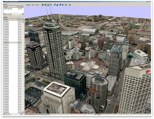
AIA Indianapolis presented and donated its 3D computer modeling tool to the Indianapolis City-County Council in July. The modeling will be used by architects, engineers, and planners of the City of Indianapolis to show how a design relates to its surrounding context, providing a more realistic view of how a proposed building would fit in. AIA Indianapolis hopes the tool also can provide more detailed building information to firefighters and police officers, such as building heights and the locations of doors and windows. A simplified version of the 3D model will be available to the public on Google Earth.
 How it works How it works
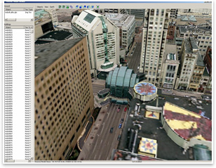
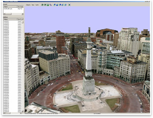
The AIA contracted with Pictometry International Corp. to create the 3D model. Precision Lightworks developed the computer program. Images—taken at angles—of downtown Indianapolis buildings were taken in the spring then overlaid on wire frames. The first test run of the 3D modeling was used by the city as part of its presentation bid for the 2012 Super Bowl.
The 3D program tool produced fly throughs to provide real-life building visual information, including details of the façades, building scale, and the materials. This information can be updated and can factor in elements of the environment, such as wind and daylight. The program, which can be used in conjunction with electronic files and electronic drawings, also gives perspectives to other structures and public spaces within downtown.
3D modeling a great tool
About the same time that AIA Indianapolis was developing its 3D computer modeling tool, the Indiana University-Purdue University Indianapolis (IUPUI) was using the same kind of tool for design of its campus master plan. Both parties decided to work together to create one “Platinum" 3D computer modeling tool, selecting Pictometry & Precision Lightworks to construct the model.
 Sarah Hempstead, AIA, LEED-AP, the president of AIA Indianapolis, spearheaded the 3D modeling project as part of AIA150. “We gave it as a gift to the city,” she says. “The city in turn was a partner with us in helping to make it happen, particularly in terms of coordination with IUPUI to make sure our model’s borders and their borders were in alignment and that the photo-mapped files were the same and usable. The city digitally houses the information. Architects and engineers can get the full photo-mapped files, while the public can get accurate modeling without the photo textures on Google Earth.” Sarah Hempstead, AIA, LEED-AP, the president of AIA Indianapolis, spearheaded the 3D modeling project as part of AIA150. “We gave it as a gift to the city,” she says. “The city in turn was a partner with us in helping to make it happen, particularly in terms of coordination with IUPUI to make sure our model’s borders and their borders were in alignment and that the photo-mapped files were the same and usable. The city digitally houses the information. Architects and engineers can get the full photo-mapped files, while the public can get accurate modeling without the photo textures on Google Earth.”
Hempstead says the 3D modeling is a great tool. “We just had a conversation about an architect working on a hotel project who is using it for shadow modeling. I know the city is talking about doing it for safety and security studies, and it’s good for context as well because it’s photorealistic,” she says. “I’ve already heard about architects using it to look at how their projects will fit into the overall city context, for example, how the height of their cornices and ridge lines relate on a larger scale than is easily witnessed when you walk down the street. We’ve also heard of people using it for wind studies.”
|