ZGF’s Light Rail Green Line Almost Ready to Go
Portland’s MAX system ventures into the underdeveloped suburban fringe
By Zach Mortice
Associate Editor
 How do you . . . extend light rail public transportation to underdeveloped suburban communities? How do you . . . extend light rail public transportation to underdeveloped suburban communities?
Summary: ZGF is continuing its long-term design stewardship of Portland’s MAX above-ground light rail system with the dual-phased installation of its Green Line. The first phase of this project will renovate Portland’s outdated Transit Mall to accommodate light rail and will bring rail service to further-east regions of suburban Multnomah and Clackamas County. The second phase will put a light rail line on the east side of the Willamette River, which will connect to the first phase’s Transit Mall extension. Because some of these suburban rail lines will be installed in sparsely developed areas, they’ll play a strong role in guiding the region’s growth sustainably.
 Coming together in time for a renewed national debate on the role of public infrastructure and transit, Zimmer Gunsul Frasca (ZGF) is putting the finishing touches on miles of new light rail lines in Portland, Ore., and is planning for further growth as well. As the president, Congress, and the AIA advocate for large-scale public infrastructure projects to become part of a comprehensive economic stimulus package, ZGF is continuing Portland’s progressive record of wisely managed urban growth. Coming together in time for a renewed national debate on the role of public infrastructure and transit, Zimmer Gunsul Frasca (ZGF) is putting the finishing touches on miles of new light rail lines in Portland, Ore., and is planning for further growth as well. As the president, Congress, and the AIA advocate for large-scale public infrastructure projects to become part of a comprehensive economic stimulus package, ZGF is continuing Portland’s progressive record of wisely managed urban growth.
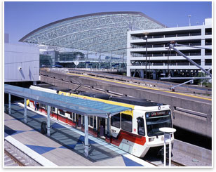
Portland’s public transportation agency (Tri-Met) introduced its MAX (Metropolitan Area Express) light rail service in 1986. Planned and designed by ZGF, MAX’s first rail line (the Blue Line) ran west-to-east along the Banfield I-84 corridor through the Portland metropolitan region.
“We’ve had our fingers in every piece of it since then,” says Ron Stewart, AIA, a principal at ZGF’s Portland office. Stewart worked on this first section and leads the MAX system’s expansion today.
An extension further west from the Blue Line came in 1998, and the Red Line, which brought passengers from the city center north to Portland’s airport, was completed in 2001. In 2004, the Yellow Line, which took passengers north from the city center to the Portland Metropolitan Exposition Center, opened its doors. Today, ZGF is designing and planning the MAX system’s Green Line in two phases, which will extend Tri-Met’s light rail reach far into suburban edge communities.
 Transitioning the Transit Mall Transitioning the Transit Mall
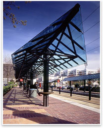
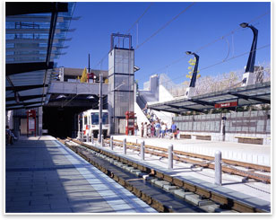
At 8.3 miles, the first phase of the Green Line (to be completed in September of this year) is divided into two sections. Within Portland’s downtown core, ZGF’s new transit line will renovate the city’s outdated and disused bus Transit Mall. Here, the Green and Yellow Line will loop from Portland’s Union Station to the north to Portland State University’s campus to the south on dedicated public transit one-way roads. This will link Portland’s other vital rail hub (Union Station) to its most popular public transit destination, as 40 percent of Portland State faculty, students, and staff use public transportation to arrive at the school. By 2025, nearly 50,000 people are expected to use the Green Line daily. Through the Transit Mall area, the above-ground light rail cars will share roads with buses and private vehicles restricted to dedicated lanes. ZGF has designed new glass train station shelters for this section of the Green Line that convey a consistently orienting and appropriately predictable definition of urban space. From a single painted steel column, these glass canopies spread out asymmetrically, offering a smartly geometric visual parallel to the twin glass spires of Portland’s iconic Oregon Convention Center, another ZGF design.
When Portland’s Transit Mall opened in 1977, it was hailed as a trend-setting example of public-transit-conscious urban design, becoming the first project of its type to earn an AIA National Honor Award. Bus routes from all over the city converged at the Mall on 5th and 6th avenues and looped through these two one-way streets. But despite this early success, the mall’s reliance on bus transportation meant it didn’t go far enough soon enough. Portland’s suburban growth patterns pulled development further along an east-west axis, which meant that the first rail lines in the city would follow this route and not incorporate the Transit Mall’s north-south axis. City leaders and urban planners intended for the Transit Mall to be incorporated into the light rail system, but no one was willing to perform basic maintenance and renovations on the mall because it was always assumed that it would soon be completely retrofitted for light rail lines. In 1996, a ballot initiative to do just that failed, and the pattern of under funding and deferred maintenance continued. “It got put off, put off, and put off—thinking they weren’t going to throw good money after bad,” Stewart says. “The longer it took to get the next piece funded, the more things deteriorated.”
 The Green Line’s 24-station Phase I is estimated to cost $575.7 million—60 percent of which is being funded by the federal government. The Green Line’s 24-station Phase I is estimated to cost $575.7 million—60 percent of which is being funded by the federal government.
From the Transit Mall, Green Line trains will follow this same route, looping north-to-south along 5th and 6th avenues, then crossing the Willamette River to travel parallel to the Red and Blue Lines. The other section of ZGF’s first phase of the Green Line lies much further to the east and extends MAX’s reach further south towards suburban communities in Multnomah and Clackamas County. It will end at Clackamas Town Center Station, a large suburban shopping center that anchors the Interstate 205 commercial corridor that this section of the Green Line runs parallel to.
Growing up with light rail
Phase II of the Green Line is in the early planning stages and won’t be completed till 2015. Its 10 stations and 7.3 miles of light rail line will cost $1.4 billion, and the federal government is again expected to pay for up to 60 percent of the project. The Portland–Milwaukie Light Rail Project extends the Green Line to suburban communities in Multnomah and Clackamas County, southeast of the city, just across the Willamette River. Traveling north, this section connects Milwaukie in Clackamas County, to the Oregon Museum of Science and Industry. It then crosses the Willamette River on a new bridge (not designed by ZGF) that will carry pedestrians, cyclists, buses, light rail, and street cars—but not private vehicles. On the west bank of the river, the transit line will connect to a new campus for the Oregon Health and Science University in the city’s newest development hotbed—the southwest waterfront. From here, it’s a short distance to the southern end of the Green Line’s Phase I at Portland State University. From the Phase II section along the Willamette River, to Portland State and the new Transit Mall, along the primary west-to-east Banfield Blue and Red Line axis, to the Phase I Interstate 205 rail corridor, the Green Line forms an upside down horseshoe.
 ZGF and Portland deserve credit for sending mass transit to places it’s not often welcome. Some of the Green Line’s suburban fringe stations are located in low-density, underdeveloped industrial and residential areas, filled with warehouses and vacant lots. ZGF and Portland deserve credit for sending mass transit to places it’s not often welcome. Some of the Green Line’s suburban fringe stations are located in low-density, underdeveloped industrial and residential areas, filled with warehouses and vacant lots.
“It’s not typical,” says Stewart. “A function of light rail is that it can go anywhere. You can take it down an existing street. You can take it to an undeveloped area and create stations, thereby creating transit-oriented development.”
By setting mass transit precedents in otherwise typical suburban communities, ZGF has given itself a role in guiding these places’ growth sustainably—provided that there’s the necessary political will and local neighborhood support needed, Stewart says. And Portland has exhibited a long history of political action to match its smart growth philosophy, especially with its urban growth boundary. The urban growth boundary (established in the 1970s) draws a line between urban and rural land and establishes strict regulations on what can be built in rural-designated areas. This outline does not remain static. Every five years the metropolitan area’s elected regional government surveys the region to make sure there is always a 20-year supply of urban-designated land for future residential growth. Stewart says this policy has helped to offer residents more housing type options and encouraged denser infill development, which in turn makes mass transit infrastructure more feasible, if not mandatory.
All of this has helped Portland gain an enviable reputation as a progressive community of rich, pedestrian-oriented urban experiences—a self-fulfilling prophecy of ascendant urban growth that is expected to bring a million people to the metropolitan area by 2030 to ride Stewart and ZGF’s rails.
|