

New park, visitors center to extol the wonders of Ol’ Man River
 Tunica
County, Miss., best known of late for its spate of casinos, is about to
acquire a facility that may encourage gamblers to drop their chips (just
for a minute!) and pause to admire the majesty of the mighty Mississippi
River. Thanks to the combined efforts of architect Williamson Pounders
Architects, PC; engineer Tetra Tech, Inc.; and landscape architect SWA
Group, Tunica Riverpark, home to a new harbor, visitors’ center,
and network of nature trails, will open this fall.
Tunica
County, Miss., best known of late for its spate of casinos, is about to
acquire a facility that may encourage gamblers to drop their chips (just
for a minute!) and pause to admire the majesty of the mighty Mississippi
River. Thanks to the combined efforts of architect Williamson Pounders
Architects, PC; engineer Tetra Tech, Inc.; and landscape architect SWA
Group, Tunica Riverpark, home to a new harbor, visitors’ center,
and network of nature trails, will open this fall.
 Except
for a small riverbank park near Tunica, tourists and residents currently
have little chance to view or enjoy the Mississippi River. Tunica’s
1999 Strategic Action Plan for Tourism
proposed that a “river experience” be developed, and the town
engaged the design team to develop a phased master plan for construction
of a riverfront park. Located at approximately River Mile 699L near Robinsonville,
the site, which includes 168 acres of parkland, periodically floods. The
average mean water level at this location is 179.7 feet above sea level,
the riverbank is at approximately 200.0 feet and the top of the levee
is at 220.0 feet. While the normal annual water level fluctuates between
165.0 and 195.0 feet, the 5-year flood mark is 202.0, the 25-year flood
mark is 208.0, and the 100-year flood mark is 213.0. The new road system
will periodically go underwater, while the buildings sit above the 100-year-flood
level.
Except
for a small riverbank park near Tunica, tourists and residents currently
have little chance to view or enjoy the Mississippi River. Tunica’s
1999 Strategic Action Plan for Tourism
proposed that a “river experience” be developed, and the town
engaged the design team to develop a phased master plan for construction
of a riverfront park. Located at approximately River Mile 699L near Robinsonville,
the site, which includes 168 acres of parkland, periodically floods. The
average mean water level at this location is 179.7 feet above sea level,
the riverbank is at approximately 200.0 feet and the top of the levee
is at 220.0 feet. While the normal annual water level fluctuates between
165.0 and 195.0 feet, the 5-year flood mark is 202.0, the 25-year flood
mark is 208.0, and the 100-year flood mark is 213.0. The new road system
will periodically go underwater, while the buildings sit above the 100-year-flood
level.
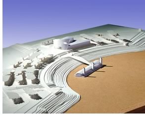 Harbor,
center, park
Harbor,
center, park
A harbor will be dredged out of the existing river bank and fitted with
a floating dock to accommodate a large excursion boat. The dock will be
a custom-built, steel floating barge with six or eight boat slips for
small transient pleasure boats and a launch ramp for public use. The docking
facility will also be able to handle the delta queen riverboats that regularly
cruise up and down the river. A harbor berm will be built in lifts of
engineered fill from dredging the harbor itself. Riprap stone, tying into
the existing trench-fill bank system, will form the harbor walls. Finally,
a large fountain proposed for the harbor will shoot a high-arching water
jet visible for miles, marking both the landside and waterside gateways
to the park.
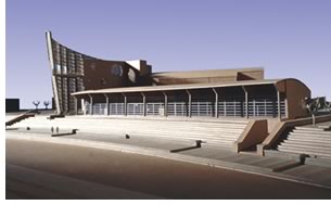
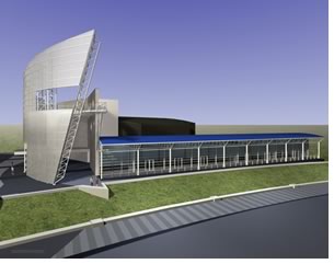
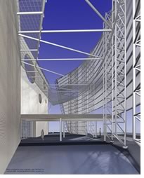 The
37,000-square-foot visitors center will serve as home to a large welcome
lobby, concession area, gift shop, meeting rooms, and river-levee museum
that includes a Mississippi River-stocked freshwater aquarium. The museum
will offer interpretive exhibits on the river’s history and its
levee system and their impact on Tunica County. Terraces overlooking the
river, a promenade along the top of the curving harbor facility, and bridges
to the nature trail system will connect outside to in, and natural to
manmade. An observation deck several stories in the air will overlook
the harbor and the river. The center also will house the administrative
spaces supporting the marina facilities.
The
37,000-square-foot visitors center will serve as home to a large welcome
lobby, concession area, gift shop, meeting rooms, and river-levee museum
that includes a Mississippi River-stocked freshwater aquarium. The museum
will offer interpretive exhibits on the river’s history and its
levee system and their impact on Tunica County. Terraces overlooking the
river, a promenade along the top of the curving harbor facility, and bridges
to the nature trail system will connect outside to in, and natural to
manmade. An observation deck several stories in the air will overlook
the harbor and the river. The center also will house the administrative
spaces supporting the marina facilities.
The “nature experience” portion of the project will include trails of varying lengths, as well as interpretative information about the wetland environment. ADA-compliant trails will be an integral part of the system. Interpretive earth forms, such as small levees and earth mounds built to help describe the historic flood levels, will be supplemented with additional landscaping. Sculptural elements, including wind sculptures and stabiles, will provide a secondary focus for the project.
Tunica County will provide funding for the $23 million project.
Copyright 2003 The American Institute of Architects.
All rights reserved. Home Page ![]()
![]()
 |
||
|
|
||